

Multi-level Semantic Retrieval Method for Landslide Disaster Data
-
摘要:如何在海量多源多模态的滑坡灾害时空大数据中快速精准地发现满足灾情评估任务需求的优势信息,是综合减灾救灾的关键. 传统灾害数据检索多以“人工经验+关键字”的被动检索方式为主,难以兼顾任务的精确性与时效性,为此,提出了一种面向评估任务的滑坡灾情数据多层级语义检索方法. 通过建立滑坡灾情评估任务对数据特征需求的显式语义描述及任务需求与数据特征之间的高级语义映射,并据此设计多层级语义匹配的数据检索算法,面向灾情评估任务实现优势数据汇聚. 以四川茂县滑坡灾害评估为例进行实验分析,本文检索方法查询效率具有明显优势,900 km 2、90 d范围内的灾情数据精准检索效率达到秒级,且推荐优势数据集的准确性高,60 d时间差距阈值下推荐结果平均贴近度达到90%以上. 结果表明本方法可根据任务需求准确可靠地快速自动获取灾害数据,从而显著提高减灾应急响应能力.Abstract:How to quickly and accurately find the superior information to meet the needs of disaster assessment tasks in massive spatio-temporal big data of landslide hazards is the key basis for comprehensive disaster reduction and disaster relief. The traditional disaster data retrieval is mainly based on the passive retrieval method of “artificial experience + keywords”, which makes it difficult to balance the accuracy and timeliness of tasks. This paper proposes a multi-level semantic retrieval method of spatio-temporal data for disaster assessment tasks. By establishing an explicit semantic description of data feature requirements and high-level semantic mapping between task requirements and data features, a multi-level semantic matching data retrieval algorithm is designed to realize superior data aggregation for disaster assessment tasks. Application of the proposed method to the landslide hazard assessment of Maoxian County in Sichuan demonstrates its high query efficiency such as a seconds-level retrieval efficiency in dealing with disaster data in a 900 km 2and 90 day range. The accuracy of the recommended dominant data set is also significant, and the average closeness of the recommended results under the 60-day time gap threshold is over 90%. The results show that the method can quickly and automatically acquire disaster data according to the mission requirements, thus significantly improving the disaster mitigation emergency response capability.
-
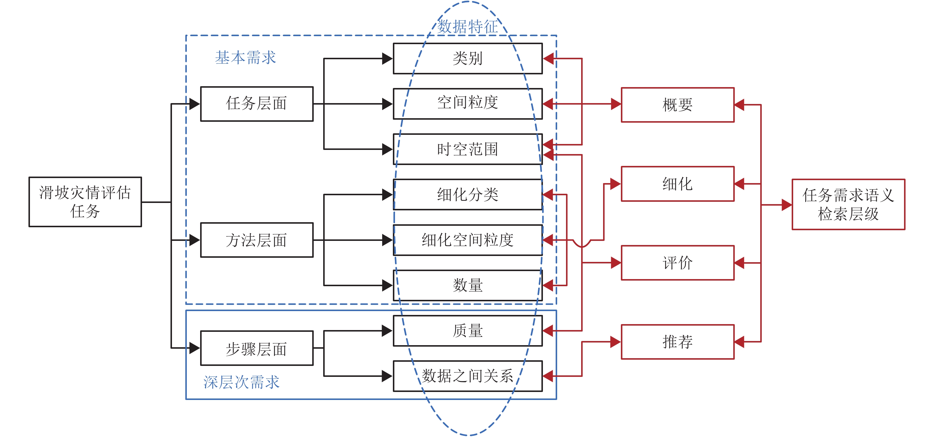
图 1面向滑坡灾情评估任务的数据多级需求语义映射
Figure 1.Multi-level requirement semantic mapping of data for landslide disaster assessment tasks
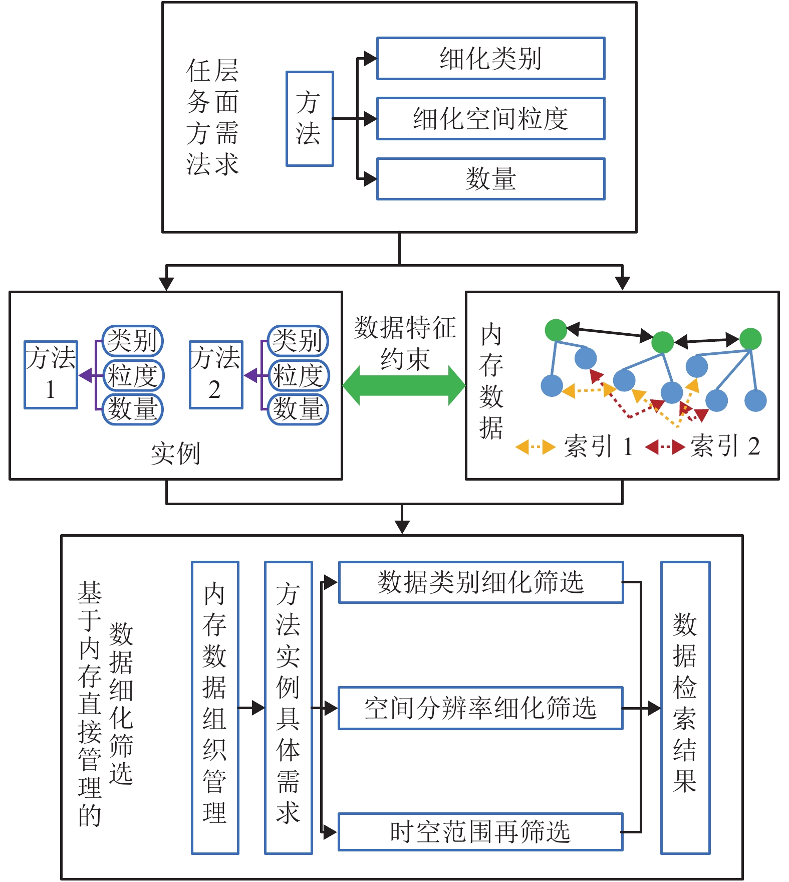
图 3基于内存直接管理的数据细化筛选流程
Figure 3.Data refinement and filtering process based on direct memory management
-
范一大,吴玮,王薇,等. 中国灾害遥感研究进展[J]. 遥感学报,2016,20(5): 1170-1184.FAN Yida, WU Wei, WANG Wei, et al. Research progress of disaster remote sensing in China[J]. Journal of Remote Sensing, 2016, 20(5): 1170-1184. 朱庆,曹振宇,林珲,等. 应急测绘保障体系若干关键问题研究[J]. 武汉大学学报(信息科学版),2014,39(5): 551-555.ZHU Qing, CAO Zhenyu, LIN Hui, et al. Key technologies of emergency surveying and mapping service system[J]. Geomatics and Information Science of Wuhan University, 2014, 39(5): 551-555. 袁艺. 自然灾害灾情评估研究与实践进展[J]. 地球科学进展,2010,25(1): 22-32.YUAN Yi. Advances in the assessment of natural disaster situation[J]. Advances in Earth Science, 2010, 25(1): 22-32. 吕雪锋,程承旗,龚健雅,等. 海量遥感数据存储管理技术综述[J]. 中国科学:技术科学,2011,41(12): 1561-1573.LÜ Xuefeng, CHENG Chengqi, GONG Jianya, et al. Review of data storage and management technologies for massive remote sensing data[J]. Science Sinica Technologica, 2011, 41(12): 1561-1573. BORKULO E V, BARBOSA V. Services for emergency response systems in the Netherlands[C]//Proceedings of the Second Symposium on Gi4DM. Goa: [s.n.], 2006: 1-6. 范一大,杨思全,王磊,等. 汶川地震应急监测评估方法研究[J]. 遥感学报,2008,12(6): 858-864.FAN Yida, YANG Siquan, WANG Lei, et al. Study on urgent monitoring and assessment in Wenchuan earthquake[J]. Journal of Remote Sensing, 2008, 12(6): 858-864. 曹振宇. 自然灾害应急测绘信息服务机制与方法[D]. 武汉: 武汉大学, 2014. 仇林遥. 面向自然灾害应急任务的时空数据智能聚合方法[D]. 武汉: 武汉大学, 2017. 夏兴生,朱秀芳,潘耀忠,等. 基于历史案例的自然灾害灾情评估方法研究[J]. 灾害学,2016,31(1): 219-225.XIA Xingsheng, ZHU Xiufang, PAN Yaozhong, et al. Study on evaluation method of natural disaster based on historical cases[J]. Journal of Catastrophology, 2016, 31(1): 219-225. 刘同来,韩飞,张万桢. 基于MapReduce的海洋异构数据快速检索方法[J]. 桂林电子科技大学学报,2018,38(5): 407-410.LIU Tonglai, HAN Fei, ZHANG Wanzhen. Map-Reducebased fast retrieval method for heterogeneous ocean data[J]. Journal of Guilin University of Electronic Technology, 2018, 38(5): 407-410. 姚梦辉,刘军旗,封瑞雪,等. 地质灾害信息存储技术及检索方法[J]. 计算机系统应用,2018,27(6): 209-213.YAO Menghui, LIU Junqi, FENG Ruixue, et al. Geological hazard information storage technology and retrieval method[J]. Computer Systems & Applications, 2018, 27(6): 209-213. 廖永丰,李博,吕雪锋,等. 基于GeoSOT编码的多元灾害数据一体化组织管理方法研究[J]. 地理与地理信息科学,2013,29(5): 36-40.LIAO Yongfeng, LI Bo, LÜ Xuefeng, et al. Method of multi-type disaster data organization and management based on GeoSOT[J]. Geography and Geo-information Science, 2013, 29(5): 36-40. DING Yulin, FAN Yida, DU Zhiqiang, et al. An integrated geospatial information service system for disaster management in China[J]. International Journal of Digital Earth, 2015, 8(11): 918-945.doi:10.1080/17538947.2014.955540 WIEGAND N, CASSANDRA G. A task-based ontology approach to automate geospatial data retrieval[J]. Transactions in GIS, 2007, 11(3): 355-376.doi:10.1111/j.1467-9671.2007.01050.x LI Ping, TAO Xiaxin, ZHANG Jinquan, et al. Retrieval module to choose satellite images by considering the demand of disaster mitigation[C]//Inter-national Conference on Remote Sensing. Nanjing: IEEE, 2011: 685-688. FAN Zhengjie, ZLATANOVA S. Exploring ontologies for semantic interoperability of data in emergency response[J]. Applied Geomatics, 2011, 3(2): 109-122.doi:10.1007/s12518-011-0048-y FAN Minghu, FAN Hong, CHEN Nengcheng, et al. Active on-demand service method based on event-driven architecture for geospatial data retrieval[J]. Computers & Geosciences, 2013, 56: 1-11. QIU Linyao, ZHU Qing, GU Jieye, et al. A task-driven disaster data link approach[J]. International Archives of the Photogrammetry Remote Sensing & S, 2015, XL-3\ISPRS: 179-186. 唐川,张军,万石云,等. 基于高分辨率遥感影象的城市泥石流灾害损失评估[J]. 地理科学,2006,26(3): 358-363.TANG Chuan, ZHANG Jun, WAN Shiyun, et al. Loss evaluation of urban debris flow hazard using high spatial resolution satellite imagery[J]. Scientia Geographica Sinica, 2006, 26(3): 358-363. 范一大. 重特大自然灾害损失综合评估进展[J]. 中国减灾,2015(21): 47. RADKE R J, ANDRA S, AL-KOFAHI O, et al. Image change detection algorithms:a systematic survey[J]. IEEE Transactions on Image Processing A Publication of the IEEE Signal Processing Society, 2005, 14(3): 294-307.doi:10.1109/TIP.2004.838698 MAULIK U, CHAKRABORTY D. Learning with transductive SVM for semisupervised pixel classification of remote sensing imagery[J]. Isprs Journal of Photogrammetry & Remote Sensing, 2013, 77(3): 66-78. BLASCHKE T. Object based image analysis for remote sensing[J]. Isprs Journal of Photogrammetry & Remote Sensing, 2010, 65(1): 2-16. 李京. 自然灾害灾情评估模型与方法体系[M]. 北京: 科学出版社, 2012: 231-232. 张宝军. 我国自然灾害情况统计制度与标准化进展[J]. 灾害学,2015,30(3): 150-155.ZHANG Baojun. Advance in system and standardization of natural disasters information statistics in China[J]. Journal of Catastrophology, 2015, 30(3): 150-155. 曹闻. 时空数据模型及其应用研究[D]. 郑州: 解放军信息工程大学, 2011. 黄宇民,范一大,马骏,等. 中国遥感卫星系统灾害监测能力研究[J]. 航天器工程,2014,23(6): 7-12.HUANG Yumin, FAN Yida, MA Jun, et al. Research on disaster monitoring ability of Chinese remote satellite system[J]. Spacecraft Engineering, 2014, 23(6): 7-12. WANG Jinnian, GU Xingfa, TAO Ming. Classifi-cation and gradation rule for remote sensing satellite data products[J]. Journal of Remote Sensing, 2013, 44(1): 80-85. 贾永红,李德仁,孙家柄. 多源遥感影像数据融合[J]. 遥感技术与应用,2000,15(1): 41-44.JIA Yonghong, LI Deren, SUN Jiabing. Data fusion techniques for multisources remotely sensed imagery[J]. Remote Sensing Technology and Application, 2000, 15(1): 41-44. 关磊,李华,苏倩,等. 公路路域生态环境遥感监测数据源选取研究[J]. 遥感技术与应用,2013,28(2): 315-323.GUAN Lei, LI Hua, SU Qian, et al. Remote sensing data selection research for road ecological environment monitoring[J]. Remote Sensing Technology and Application, 2013, 28(2): 315-323. KANUNGO T, MOUNT D M, NETANYAHU N S, et al. An efficient k-means clustering algorithm:analysis and implementation[J]. IEEE Transactions on Pattern Analysis and Machine Intelligence, 2002, 24(7): 881-892.doi:10.1109/TPAMI.2002.1017616 -

 下载:
下载:


 点击查看大图

图(6)
计量
- 文章访问数:783
- HTML全文浏览量:423
- PDF下载量:27
- 被引次数:0